appdownload.guide
APP
OsmAnd — Maps & GPS Offline
OsmAnd
4.4(200K)
10M Downloads
Travel & Local
Ratings & Reviews
4.4
200K Reviews
5★
149.7K
4★
20.9K
3★
10.9K
2★
4.3K
1★
14.3K
App Info
DeveloperOsmAnd
CategoryTravel & Local
Downloads10M+
PriceFree
Updated2025-05-31
Key Features
Navigate offline with customizable routes for different vehicles, ensuring accurate guidance.
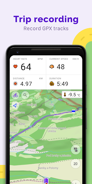
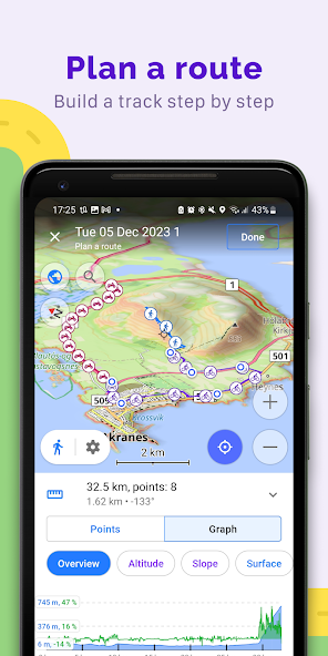
Plan routes point by point and record GPX tracks to explore areas without internet connectivity.
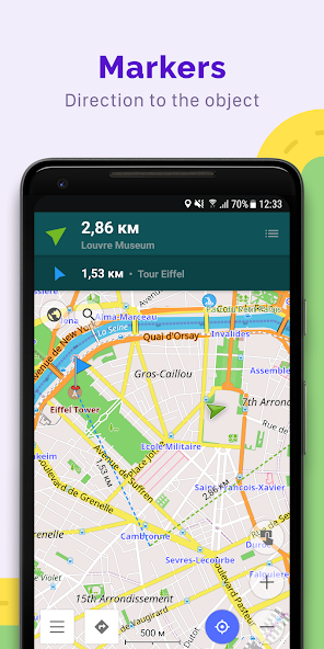
Create personalized points of interest with favorites, markers, and audio/video notes for easy access.
Access up-to-date OpenStreetMap data and make real-time edits for accurate information.
Discover top-ranked POIs, search OSM routes, and customize widgets for a tailored navigation experience.
Screenshots
Trailer
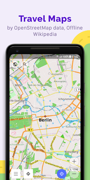
Transform your experience with OsmAnd — Maps & GPS Offline, where capability meets design. Whether you're a seasoned traveler or just exploring your local surroundings, this offline world map app based on OpenStreetMap (OSM) revolutionizes the way you navigate.
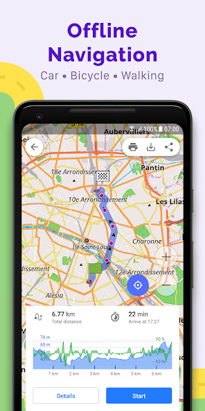
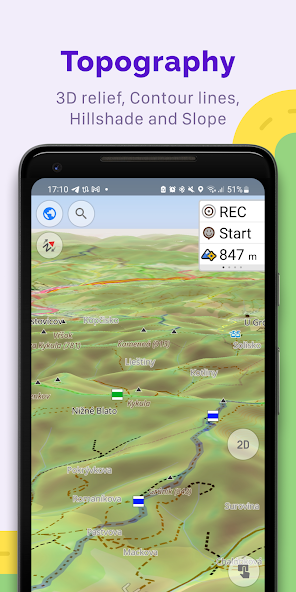
Say goodbye to getting lost in unfamiliar territories or dealing with spotty internet connections. With OsmAnd, plan your routes based on inclines and vehicle dimensions even without an internet connection. Explore various map styles tailored for different activities like touring, nautical adventures, skiing, off-roading, and more.
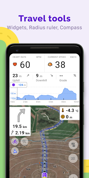
Navigate like a pro with customizable profiles for different vehicles – cars, motorcycles, bicycles, and even boats. Tweak your route preferences by excluding specific roads or surfaces to tailor your journey exactly how you want it. Stay informed with real-time widgets displaying crucial information like distance, speed, and remaining travel time.
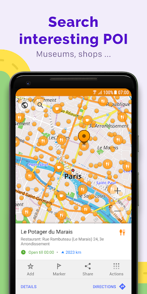
Plotting routes point by point using multiple navigation profiles is a breeze with OsmAnd. Record your adventures with GPX tracks and share them on OpenStreetMap. Discover new places effortlessly with the ability to search for attractions, food spots, health facilities, and more.
Explore top-ranked points of interest with the new Explore mode and easily find hiking trails, cycling paths, and mountain biking routes. Stay updated on the go with hourly map updates and take advantage of features like compass and radius ruler for added convenience.
With paid features like Maps+ and OsmAnd Pro offering Android Auto support, unlimited map downloads, offline Wikipedia access, backup options via OsmAnd Cloud, weather plugins, elevation widgets – the possibilities are endless.
Enhance your daily travels with OsmAnd — Maps & GPS Offline today. Your next adventure awaits!
About This App
1. Are you tired of getting lost when traveling? Looking for a reliable offline map solution that puts you in control of your navigation? Look no further than OsmAnd — Maps & GPS Offline!
2. OsmAnd is your ultimate travel companion, offering detailed offline maps based on OpenStreetMap (OSM) data. With advanced features tailored to your specific needs, this app ensures you can explore the world with confidence, even without an internet connection.
3. Key features and benefits:
- Customize map views with various styles for different activities
- Plan routes based on inclines and vehicle dimensions
- Navigate using customizable profiles for different vehicles
- Record GPX tracks and share them easily
- Access additional features like compass, radius ruler, and more
4. Real-world use cases and examples:
- Plan a scenic road trip with custom route preferences
- Explore hiking trails or cycling routes confidently
- Share favorite destinations with friends using GPX tracks
- Edit OpenStreetMap data to contribute to the community
5. Technical specifications: N/A
6. User testimonials or social proof: "OsmAnd has been a game-changer for my outdoor adventures! The detailed maps and customizable navigation options make exploring new places a breeze." - Happy User
7. Ready to take control of your travels and explore the world on your terms? Download OsmAnd — Maps & GPS Offline now and unlock a whole new level of navigation freedom!
What's New
Explore new top-ranked Points of Interest easily with the updated Explore mode. Search for all OpenStreetMap routes, including hiking, cycling, and MTB trails. Our latest navigation widget now combines turn arrows with clear navigation instructions for a seamless experience. Stay informed with the new current route info widget that displays your ETA, arrival time, and distance. Dive deeper into ski slopes and MTB trails by selecting them on the map to access detailed information. Customize your experience by choosing widget sizes for both left and right panels. Additionally, we've added a "Coordinates grid" feature to view geographical coordinates.
Update now to enjoy these exciting new features and enhance your navigation experience!
User Reviews
Ananya Patel
May 29, 2025
OsmAnd is a fantastic tool for hiking enthusiasts like me. The ability to overlay topographic maps and record GPX tracks offline is invaluable. However, the interface could be more intuitive.
Anna Kowalski
May 29, 2025
I rely on OsmAnd for my cycling adventures and it rarely disappoints. The elevation widget provides crucial information during rides. However, the lack of Android Auto support in the free version limits its usability while driving.
David Kim
May 29, 2025
As a frequent traveler, I appreciate the diverse map styles OsmAnd offers. The offline navigation works well, but I encountered occasional inaccuracies in route planning that were frustrating.
Mohammed Al-Farsi
May 29, 2025
While the map editing feature in OsmAnd is commendable, I found the map updates to be infrequent for my area. The paid Maps+ subscription should include more frequent map updates to justify its cost.
Priya Sharma
May 29, 2025
OsmAnd has become my go-to app for road trips with friends. Customizable navigation profiles for different vehicles make planning journeys seamless. The feature to share GPX tracks on OpenStreetMap is a game-changer!
Ratings & Reviews
4.4
200K Reviews
5★
149.7K
4★
20.9K
3★
10.9K
2★
4.3K
1★
14.3K
App Info
DeveloperOsmAnd
CategoryTravel & Local
Downloads10M+
PriceFree
Updated2025-05-31
Key Features
Navigate offline with customizable routes for different vehicles, ensuring accurate guidance.
Plan routes point by point and record GPX tracks to explore areas without internet connectivity.
Create personalized points of interest with favorites, markers, and audio/video notes for easy access.
Access up-to-date OpenStreetMap data and make real-time edits for accurate information.
Discover top-ranked POIs, search OSM routes, and customize widgets for a tailored navigation experience.