appdownload.guide
APP
Zoom Earth - Weather Forecast
Neave Interactive
4.7(177K)
1M Downloads
Weather
Ratings & Reviews
4.7
177K Reviews
5★
145.2K
4★
17.4K
3★
7.2K
2★
2.2K
1★
5.3K
App Info
DeveloperNeave Interactive
CategoryWeather
Downloads1M+
PriceFree
Updated2025-09-29
Key Features
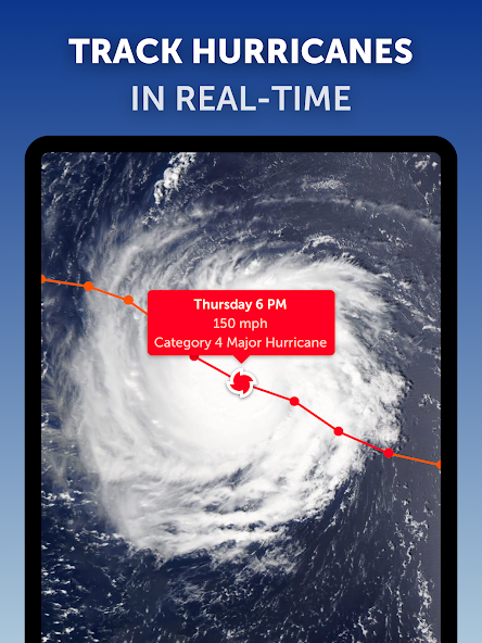
Real-time hurricane tracking for up-to-date storm monitoring and preparedness.
Interactive weather radar with nowcasting for accurate short-term forecasts.
Customizable settings to tailor temperature units, wind units, and more to your preference.
High-definition satellite imagery updated regularly for detailed weather visualization.
Tropical tracking system providing clear and easy-to-understand hurricane information.
Screenshots


Simplify your tasks in Zoom Earth - Live Weather Map, where your decisions are informed.
Track the weather in real-time and gain access to a wealth of valuable information at your fingertips. With Zoom Earth, you can explore interactive weather maps showcasing rain, wind, temperature, pressure, and more. Stay ahead of severe weather conditions by monitoring hurricanes, storms, wildfires, and smoke with near real-time satellite imagery and rain radar updates.
Visualize the world's weather patterns with stunning satellite imagery updated every 10 minutes from various geostationary satellites. Stay informed about current conditions and forecast models with HD images from NASA polar-orbiting satellites Aqua and Terra.
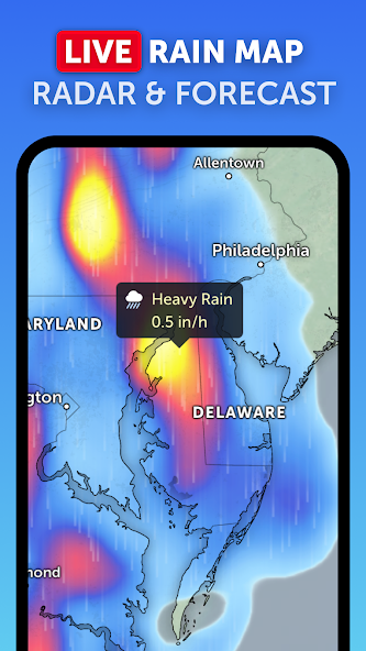
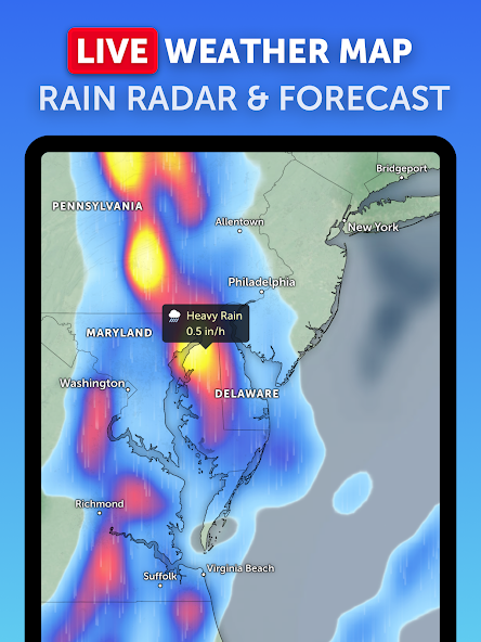
Stay one step ahead of storms with our weather radar map that detects rain and snow in real-time. Get instant short-term weather forecasts through radar nowcasting to plan your day effectively.
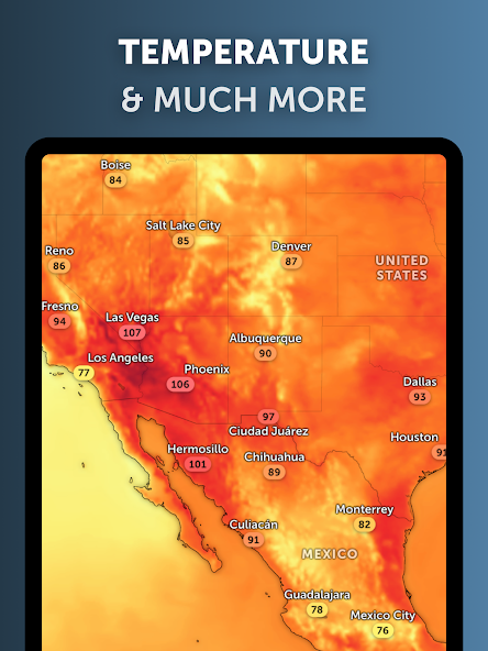
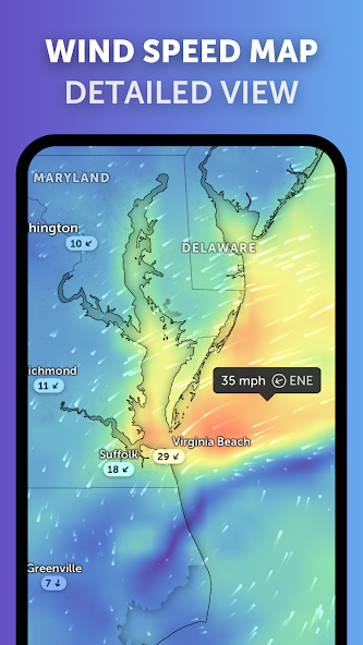
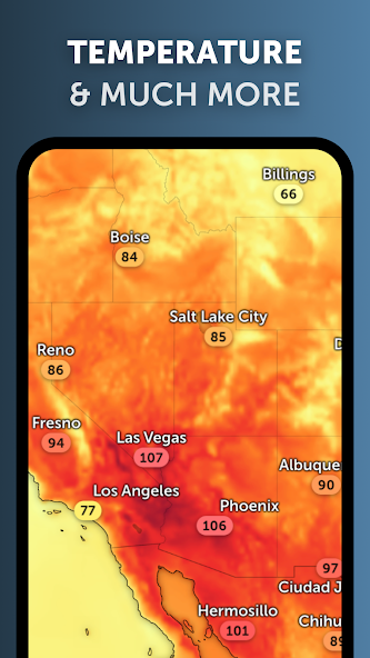
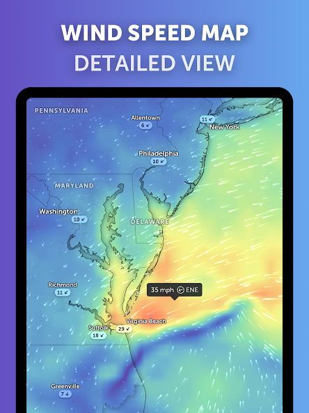
Explore our beautiful global forecast maps featuring precipitation forecasts, wind speed and gusts predictions, temperature forecasts, humidity levels, dew points, and atmospheric pressure forecasts. Know what to expect at a glance for better decision-making.
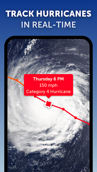
Follow hurricanes from development to category 5 in real-time using our top-notch tropical tracking system. Get clear and easy-to-understand information updated with the latest data sources.
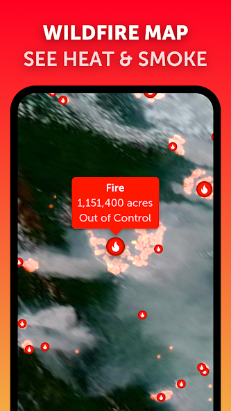
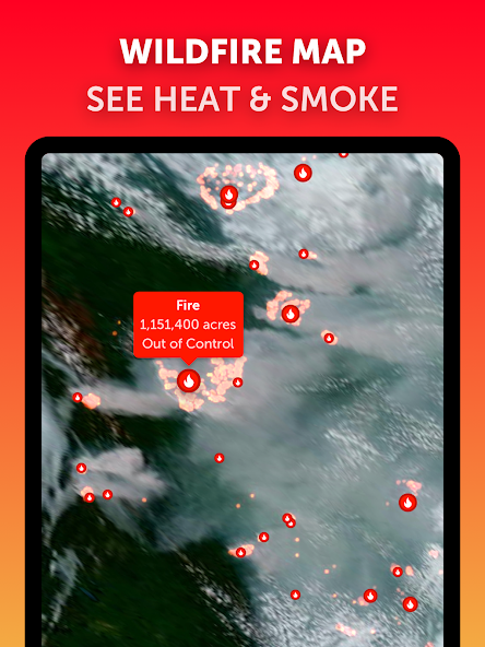
Monitor wildfires closely with active fires and heat spots overlay that provides daily updates on high-temperature points detected by satellites. Use GeoColor satellite imagery to track wildfire smoke movement accurately.
Customize your experience by adjusting temperature units, wind settings, time zones, animation styles, and more within our comprehensive settings menu.
Discover even more features with Zoom Earth Pro through auto-renewable subscriptions for enhanced functionality. Take advantage of improved Meteosat-12 imagery for Europe and Africa alongside a new dark theme setting for Precipitation and Radar maps.
Zoom Earth simplifies weather tracking so you can make informed decisions effortlessly. Download now to experience the ultimate tool for staying ahead of changing weather conditions!
About This App
Introducing Zoom Earth - Live Weather Map, your ultimate tool for tracking the weather in real-time. Stay informed about global weather patterns and keep an eye on hurricanes, storms, wildfires, and more with this interactive app.
Key Features:
- Satellite Imagery: View near real-time satellite images updated every 10 minutes from various geostationary satellites.
- Rain Radar & Nowcast: Stay ahead of storms with ground-based Doppler radar detection and instant short-term weather forecasts.
- Weather Forecast Maps: Explore detailed visualizations including precipitation forecast, wind speed, temperature forecast, and more.
- Hurricane Tracking: Monitor hurricanes from development to category 5 using the latest data from reputable sources.
- Wildfire Tracking: Keep tabs on active fires and heat spots with daily updates from NASA FIRMS data.
Real-world Use Cases:
- Plan outdoor activities based on accurate weather forecasts.
- Stay safe during severe weather events by tracking developments in real-time.
- Monitor wildfire movements to assess potential risks in your area.
With customizable settings and a pro version offering additional features through subscriptions, Zoom Earth caters to both casual users and weather enthusiasts alike.
Don't miss out on the latest improvements like Meteosat-12 imagery for Europe and Africa, a new Dark Theme setting for map display, and other minor fixes that enhance your user experience.
Stay ahead of the weather curve with Zoom Earth - download now!
---
Note: The description has been tailored to emphasize practicality, efficiency, and problem-solving capabilities while avoiding clichés or marketing jargon.
What's New
What's new: In this update, we bring you enhanced imagery for Europe and Africa with the latest Meteosat-12 satellite. Experience improved visuals thanks to EUMETSAT’s cutting-edge technology. Additionally, you can now switch to a Dark Theme to view Precipitation and Radar maps in a sleeker style. We've also included various minor fixes and enhancements to elevate your app experience. Update now to enjoy these new features!
Our Review
This weather app offers real-time tracking of global weather conditions, hurricanes, and wildfires.
Key Strengths:
The app provides detailed satellite imagery updated every few minutes, offering a clear view of weather patterns.
The hurricane and wildfire tracking features are comprehensive and informative, keeping users aware of potential threats.
Customization options allow users to tailor the app to their preferences for a personalized experience.
Areas for Improvement:
While the app's features are impressive, the interface could be more intuitive for new users.
Some advanced features are only available through subscriptions, limiting access to certain functionalities.
Overall, Zoom Earth - Live Weather Map is recommended for users seeking a reliable tool for monitoring weather events globally. With regular updates and in-depth data, it is a valuable resource for staying informed about changing weather conditions.
User Reviews
David Kim
May 29, 2025
As a frequent traveler, Zoom Earth has become my go-to weather companion. The wind speed forecast feature has been particularly helpful in planning outdoor activities during my trips.
Emily S.
May 29, 2025
Zoom Earth helped me track a storm approaching my area accurately. The live satellite imagery was impressive and the hurricane tracking feature was spot on.
Javier L.
May 29, 2025
I found the wildfire tracking useful, but the app can be slow to load at times. Overall, a decent tool for monitoring weather conditions.
Luisa Santos
May 29, 2025
I encountered some bugs while using the app, especially when switching between different forecast maps. The hurricane tracking feature is great when it works, but reliability is an issue.
Priya Patel
May 29, 2025
The customization options are fantastic! Being able to adjust units and settings makes the app very user-friendly. However, I wish the radar map had more detailed information.
Ratings & Reviews
4.7
177K Reviews
5★
145.2K
4★
17.4K
3★
7.2K
2★
2.2K
1★
5.3K
App Info
DeveloperNeave Interactive
CategoryWeather
Downloads1M+
PriceFree
Updated2025-09-29
Key Features
Real-time hurricane tracking for up-to-date storm monitoring and preparedness.
Interactive weather radar with nowcasting for accurate short-term forecasts.
Customizable settings to tailor temperature units, wind units, and more to your preference.
High-definition satellite imagery updated regularly for detailed weather visualization.
Tropical tracking system providing clear and easy-to-understand hurricane information.