appdownload.guide
APP
Avenza Maps: Offline Mapping
Avenza Systems Inc.
4.7(92.6K)
5M Downloads
Maps & Navigation
Ratings & Reviews
4.7
92.6K Reviews
5★
75.2K
4★
12.8K
3★
1.7K
2★
646
1★
2.3K
App Info
DeveloperAvenza Systems Inc.
CategoryMaps & Navigation
Downloads5M+
PriceFree
Updated2025-05-31
Key Features
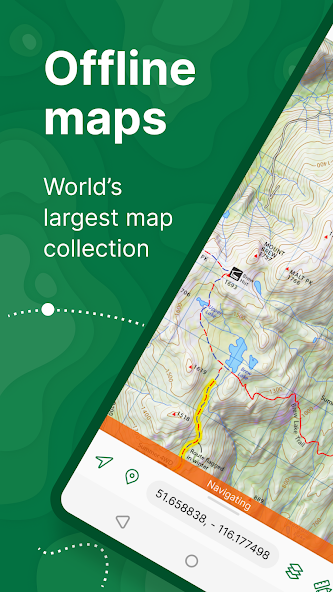
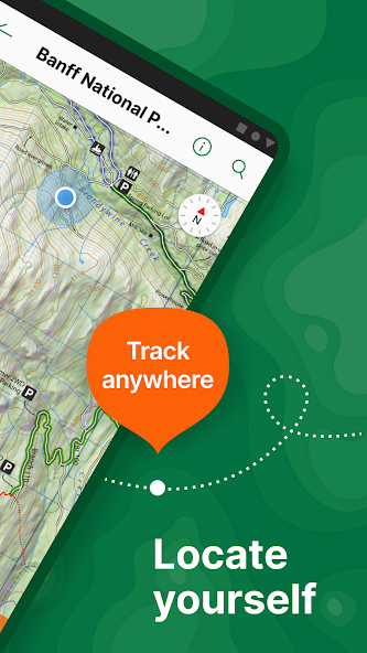
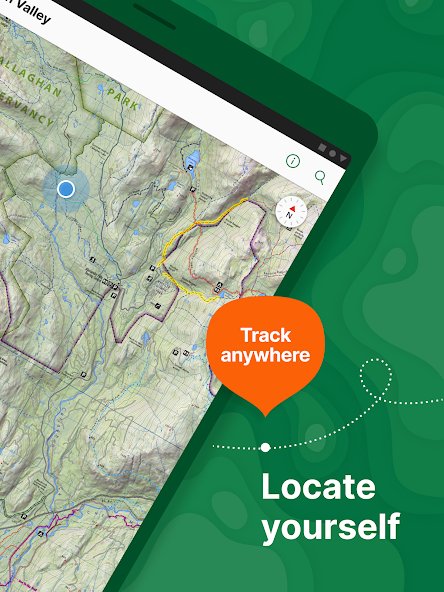
Locate your realtime GPS position and find direction, even when offline. Never get lost on trails.
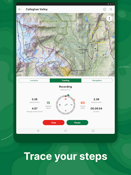
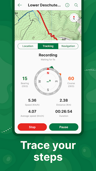
Record GPS tracks during your activities. Easily track your hiking or biking routes.
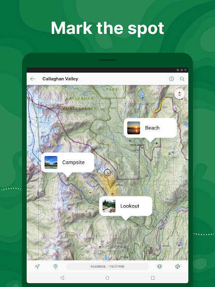
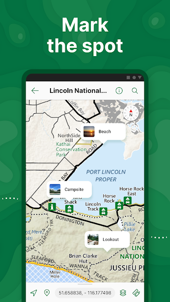
Add photos and notes to any location. Personalize your maps with memories.
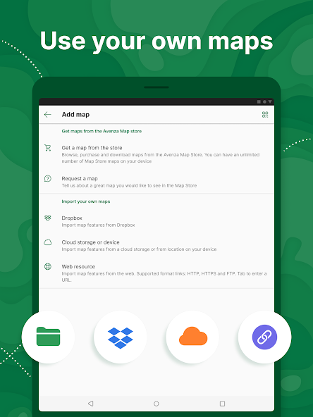
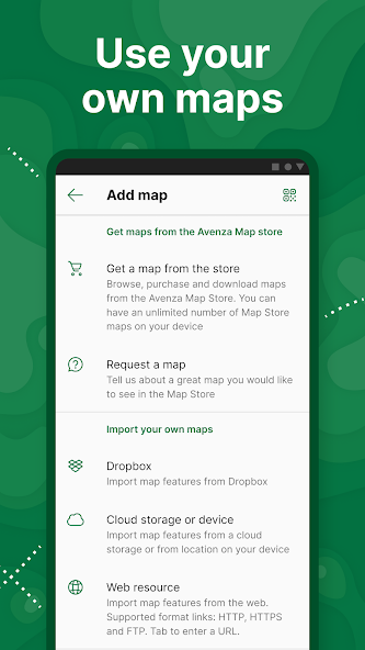
Unlimited import of your own geospatial PDF, GeoPDF®, and GeoTIFF maps. Customize maps to fit your needs.
Connect high-accuracy GPS devices including Trimble, Bad Elf, and Dual via Bluetooth. Enhance location accuracy.
Screenshots

Improve your workflow with Avenza Maps: Offline Mapping, where your experience is enhanced. Whether you're trekking through the wilderness or exploring a new city, this app is your ultimate companion for all things maps and navigation.
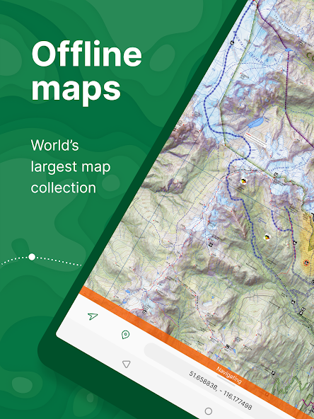
Picture this: you're hiking in a remote national park with no cell service in sight. Thanks to Avenza Maps, you can rely on offline mobile maps to keep you on track using GPS, ensuring you never lose your way in the great outdoors again.
But the benefits don't stop there. Imagine creating your custom maps for that hidden gem camping spot or secret fishing hole. With Avenza Maps, you can import these personalized maps and confidently venture off-grid without fear of getting lost.
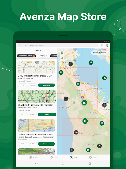
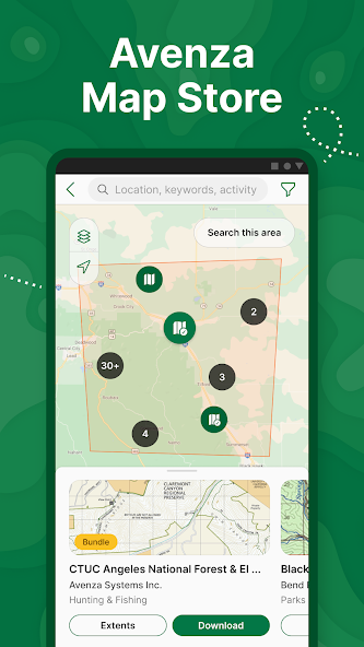
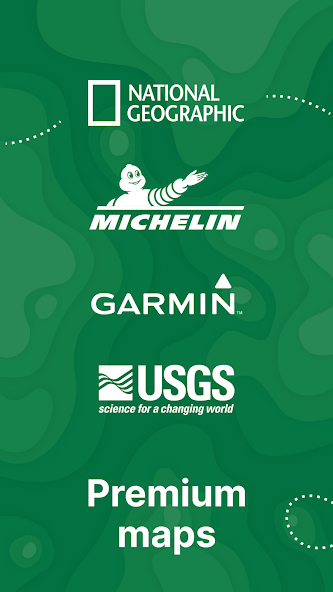
What sets Avenza Maps apart is its extensive Map Store, offering a vast selection of topographic, cycling, city, nautical, and trail maps from renowned publishers like National Geographic and the US Forest Service. Whether you're planning a family camping trip or embarking on a solo backpacking adventure, finding the perfect map for your journey is just a tap away.
Stay ahead of the curve with features like locating your GPS position in real-time even offline, recording GPS tracks during activities, adding photos and notes to locations, measuring distances, and more. Plus, Avenza Maps supports various file formats for seamless integration of your data.
For those craving more customization options and advanced tools, Avenza Maps Plus and Pro subscriptions offer unlimited imports of geospatial PDFs and GeoTIFF maps, geofencing capabilities, high-accuracy GPS device connectivity, Esri® Shapefile support, and priority technical assistance.
Exciting updates in this version include a revamped UI for Placemarks, Tracks, Lines, and Areas; third-party sign-in support; multiple geofences per map feature; as well as bug fixes and performance enhancements – all designed to elevate your mapping experience further.
Ready to enhance your outdoor adventures with precision navigation? Download Avenza Maps today and unlock a world of possibilities at your fingertips. Your next thrilling expedition awaits – let's get mapping!
About This App
Step into the world of Avenza Maps, the ultimate app for hiking, biking, and all trail adventures. With access to a wide range of maps from top publishers like National Geographic and the National Park Service, you can explore with confidence both online and offline. Never lose your way off the grid again!
**Key Features & Benefits: **
- Real-time GPS positioning and directions even when offline
- Record GPS tracks to review your activities later
- Compass tools for easy navigation to features
- Add photos, notes, and placemarks to customize your map experience
- Measure distances and estimate travel times for better planning
**Real-world Use Cases: **
1. **Hiking: ** Plan your next hiking trip with detailed topographic maps.
2. **Camping: ** Find campsites with ease using maps from trusted sources like the US Forest Service.
3. **Off-roading: ** Navigate challenging terrains confidently with accurate location tracking.
**Technical Specifications: **
- Supports KML, GPX, and CSV formats for seamless data integration
- Import and export Esri® Shapefiles for advanced mapping needs
**User Testimonials: **
"I rely on Avenza Maps for all my outdoor adventures. It's like having a personal guide in my pocket!" - Sarah M.
"Thanks to Avenza Maps, I discovered hidden gems in national parks that I never knew existed." - John D.
Ready to elevate your outdoor experiences? Download Avenza Maps now and start exploring like never before!
What's New
Welcome to the latest version of Avenza Maps!In this update, we have introduced a refreshed user interface for Placemarks, Tracks, Lines, and Areas. Additionally, you can now sign in using third-party accounts and set multiple geofences per map feature. We've also addressed various bugs and made performance enhancements.Update now to explore these new features and improvements!
Our Review
This app is a powerful tool for outdoor enthusiasts, offering offline maps for hiking, biking, and more.
Key strengths:
- Access to a vast Map Store with maps from renowned publishers like National Geographic.
- Ability to import custom maps for personalized adventures.
- Varied features including GPS tracking, geofencing, and map customization.
Areas for improvement:
- The user interface could be more intuitive for first-time users.
- Some advanced functionalities are restricted to paid subscriptions.
Overall, Avenza Maps is a valuable companion for off-grid explorations. While it may have a learning curve, the range of features and map options make it worth considering for outdoor enthusiasts seeking reliable navigation tools.
User Reviews
Ananya Singh
May 29, 2025
The geofencing feature in Avenza Maps Plus has been incredibly useful for marking boundaries during my surveying projects. Highly recommended!
Carlos Morales
May 29, 2025
While the map store offers a wide range of options, I found it hard to navigate and filter specific maps for fishing locations.
Emily Patel
May 29, 2025
Avenza Maps helped me discover hidden trails in my area with detailed maps. The offline GPS feature is a game-changer for hiking adventures.
Leila Kim
May 29, 2025
Avenza Maps is my go-to for off-roading trips. The ability to import custom maps ensures I never lose my way exploring remote areas.
Ravi Gupta
May 29, 2025
I love the map selection, but sometimes the app lags when loading large files. Overall, a valuable tool for outdoor enthusiasts.
Ratings & Reviews
4.7
92.6K Reviews
5★
75.2K
4★
12.8K
3★
1.7K
2★
646
1★
2.3K
App Info
DeveloperAvenza Systems Inc.
CategoryMaps & Navigation
Downloads5M+
PriceFree
Updated2025-05-31
Key Features
Locate your realtime GPS position and find direction, even when offline. Never get lost on trails.
Record GPS tracks during your activities. Easily track your hiking or biking routes.
Add photos and notes to any location. Personalize your maps with memories.
Unlimited import of your own geospatial PDF, GeoPDF®, and GeoTIFF maps. Customize maps to fit your needs.
Connect high-accuracy GPS devices including Trimble, Bad Elf, and Dual via Bluetooth. Enhance location accuracy.